Construction surveying is a critical aspect of the building and infrastructure development process that plays an essential role in ensuring accuracy, efficiency, and compliance. Before construction can begin, the area must be mapped and staked to ensure utmost accuracy. As an experienced team of professional land surveyors in Colorado, we’re happy to break down the process for you.
In this article we’ll cover:
- What is Construction Surveying
- Why Do You Need Surveying In Construction?
- Construction Survey Equipment
- Reading Construction Survey Stakes
- Finding Your Ideal Construction Surveyor
- Premiere Colorado Surveying Services
What is Construction Surveying?
Construction surveying, also known as engineering surveying, is a specialized branch of land surveying that focuses on the collection and analysis of data required for the planning, design, and execution of construction projects. It plays a crucial role in ensuring that buildings, roads, bridges, and other infrastructure elements are built according to the approved plans, specifications, and regulatory requirements.
The primary objective of construction surveying is to establish accurate reference points, elevations, and layout information that guide the construction process from start to finish. By providing precise measurements and spatial data, construction surveyors help engineers, architects, and contractors make informed decisions, minimize errors, and maintain quality control throughout the project.
Some key tasks performed by construction surveyors include:
- Site Investigation: Before the commencement of a construction project, surveyors conduct a thorough examination of the site to gather essential information such as topography, soil conditions, drainage patterns, and existing structures. This data is used to create detailed site plans and identify potential challenges that may impact the project.
- Staking and Layout: Construction surveyors establish and mark critical reference points on the site, such as property boundaries, building corners, and utility locations. These reference points, or stakes, are used by contractors to guide the construction process and ensure that all elements are built in the correct location and alignment.
- Monitoring and Verification: Throughout the construction process, surveyors monitor the progress of the project and verify that the work is being carried out according to the design specifications. They perform regular checks on the position, elevation, and alignment of the structures, making sure that any deviations are promptly identified and corrected.
- As-Built Surveying: Upon completion of the project, construction surveyors conduct a final survey to document the completed works and create an as-built record. This record serves as a reference for future maintenance, modifications, or expansion of the infrastructure.
- Volume and Quantity Calculations: Construction surveyors also provide calculations for cut and fill volumes, material quantities, and stockpile measurements, which are crucial for cost estimation, resource management, and progress reporting.
In summary, construction surveying is an indispensable aspect of the building and infrastructure development process. By providing accurate spatial data and ensuring strict adherence to design specifications, construction surveyors contribute significantly to the success, safety, and sustainability of any construction project.
Why Do You Need Surveying In Construction?
Surveying is essential in construction to ensure that projects are accurately planned and developed according to design specifications. It helps determine land safety, identify potential issues like boundaries and topographical features, and prevent damage to existing infrastructure. Additionally, surveying ensures compliance with regulations and can save both time and money by optimizing resources and reducing unnecessary work.
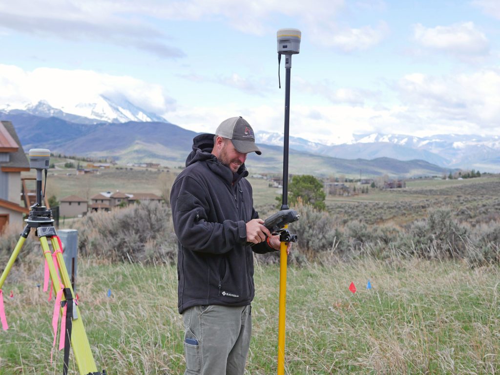
Construction Survey Equipment
Construction surveyors utilize a variety of advanced equipment and tools to collect, analyze, and present spatial data required for construction projects. These instruments help ensure accuracy, efficiency, and reliability in the measurements and layouts that guide the construction process. Here are some of the most commonly used construction survey equipment:
- Total Stations: A total station is a versatile electronic instrument that combines the functions of a theodolite and an electronic distance measurement (EDM) device. It allows surveyors to measure angles and distances with high precision, providing accurate information on the position, elevation, and alignment of various points on the construction site.
- GPS/GNSS Receivers: Global Positioning System (GPS) or Global Navigation Satellite System (GNSS) receivers use satellite signals to determine the precise location and elevation of points on the earth’s surface. These devices enable surveyors to collect real-time, accurate geospatial data, even in remote or inaccessible areas, without the need for line-of-sight measurements.
- Levels: Levels are essential optical instruments used by surveyors to determine the height differences between points and establish a horizontal plane. There are various types of levels, such as automatic levels, digital levels, and laser levels, each offering different levels of accuracy and ease of use.
- 3D Laser Scanners: 3D laser scanners emit laser beams to capture the shape, size, and position of objects and surfaces within their range. They generate millions of data points, known as point clouds, which can be processed to create highly detailed and accurate 3D models of the construction site or structure.
- Drones/UAVs: Unmanned Aerial Vehicles (UAVs) or drones equipped with high-resolution cameras or LiDAR sensors have become popular tools for construction surveying. They allow surveyors to quickly capture aerial images and topographic data, even in challenging terrain or large-scale projects, reducing the time and effort required for data collection.
- Data Collectors: Data collectors are handheld devices or tablets that enable surveyors to record, store, and manage the data obtained from various survey instruments. They often come with built-in software for data processing, analysis, and visualization, allowing surveyors to generate maps, reports, and other deliverables on-site.
- Measuring Tapes and Wheels: While more technologically advanced tools have become prevalent, measuring tapes and wheels still play a crucial role in construction surveying. They are used for quick measurements of linear distances, particularly when high precision is not required or when electronic instruments are not available.
- Safety Equipment: Construction surveyors work in diverse environments and often encounter hazards such as heavy machinery, uneven terrain, and adverse weather conditions. Therefore, they must be equipped with appropriate safety gear, including hard hats, high-visibility vests, safety boots, and protective eyewear.
In conclusion, the wide range of construction survey equipment available today has revolutionized the way surveyors collect and analyze data. By leveraging these advanced tools and technologies, construction surveyors can provide accurate, reliable, and efficient solutions that contribute significantly to the success of any construction project.
Reading Construction Survey Stakes
Construction survey stakes are essential markers used by surveyors to establish reference points and convey important information about the layout, elevation, and alignment of a construction project. These stakes guide contractors, engineers, and other construction professionals throughout the building process. To read construction survey stakes correctly, it is crucial to understand the various markings, colors, and symbols that can be found on them.
Here is a step-by-step guide on how to read construction survey stakes:
- Identify the Stake Type: There are different types of stakes used in construction surveying, each serving a specific purpose. Some common stake types include:
- Hub and Tack: A wooden or metal stake with a tack at the top, used to mark precise points such as property corners or building foundations.
- Grade Stakes: Stakes used to indicate the desired elevation or grade of a particular location, often marked with a “G” or “GRD.”
- Slope Stakes: Stakes that provide information about the slope or angle of a surface, usually marked with an “S” or “SLP.”
- Offset Stakes: Stakes placed parallel to a feature or boundary, used when direct access is not possible or to avoid disturbing the original point.
- Examine the Markings: Survey stakes typically have information written or engraved on them, such as numbers, letters, or symbols. These markings convey critical data about the stake’s purpose and the construction project. Some common markings include:
- Elevation: The elevation or height above sea level, usually expressed in feet or meters. This information is vital for grading, drainage, and ensuring proper leveling of structures.
- Cut or Fill: The amount of soil that needs to be removed (cut) or added (fill) to achieve the desired grade. Cut values may be marked with a minus sign (-) or “C,” while fill values may be marked with a plus sign (+) or “F.”
- Station: A reference number indicating the stake’s position along a linear feature, such as a road or pipeline. Stations are typically measured in increments of 100 feet or meters from a starting point.
- Offset Distance: The distance from the stake to a specific feature or boundary, usually measured perpendicular to the feature.
- Note the Colors: Survey stakes are often painted or flagged with colored ribbons to make them more visible and convey additional information. Each color may represent a different aspect of the project, such as property boundaries, utilities, or grading limits. Familiarize yourself with the color-coding system used by your surveyor or local jurisdiction to interpret the stakes correctly.
- Check for Additional Symbols: Some stakes may have symbols or abbreviations that provide further information about the stake’s purpose or the construction element it represents. For example, “W” could indicate a water line, “SS” might signify a sanitary sewer, and “EP” may denote an electrical pole.
Reading construction survey stakes accurately is crucial for ensuring that the construction process proceeds according to the design specifications and regulatory requirements. By understanding the various types, markings, colors, and symbols used on survey stakes, construction professionals can better interpret the information provided by surveyors and minimize errors throughout the project.
Finding Your Ideal Construction Surveyor
Choosing your ideal construction surveyor is important for an efficient, accurate staking process. Construction surveying is a vital component of the building process that ensures accuracy, quality, and compliance in various construction projects. If you’re based in Colorado, examine our list of top land surveying firms to find candidates that meet your needs.
When choosing a construction surveyor, you’ll want to ensure they have experience with similar projects and can adapt to the dynamic nature of construction sites. Consider factors such as experience, expertise, state-of-the-art equipment, and a proven track record of successful projects. They must effectively communicate and collaborate with other professionals on site, anticipating and addressing potential conflicts. If you’re working with a firm that offers construction administration services, they may be able to handle coordinating your surveys and other team members seamlessly. Additionally, the surveyor should be skilled at multitasking, managing various demands, and ensuring precision to avoid costly errors.
Premier Colorado Surveying Services
At Roaring Fork Engineering, we pride ourselves on offering top-notch surveying services that meet these criteria. Our team of skilled professionals utilizes cutting-edge technology and industry best practices to deliver accurate, efficient, and dependable solutions for your construction surveying needs. Contact us today to learn more about how Roaring Fork Engineering can help make your next project a success.
Last updated August 2nd, 2024